GEOTECHNICAL ENGINEERING
COLUMBUS OHIO
HomeInvestigationExploratory test pit

Exploratory Test Pit Services for Site Characterization in Columbus Ohio

Sound ground. Sound decisions.

LEARN MORE

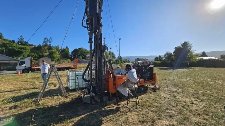
Between the limestone bedrock of Dublin and the alluvial deposits of the Scioto River in Franklinton, the subsurface conditions across Columbus change dramatically within half a mile. A site in Hilliard might sit on thick, stiff glacial till, while a property near Ohio State’s campus can encounter buried organic silts from pre-settlement drainage patterns. We’ve learned from hundreds of projects that relying on boring logs alone misses the lateral variability that only an exploratory test pit reveals. By excavating a controlled opening, our crew logs soil stratification, measures in-situ density with a sand cone density apparatus right at the trench wall, and identifies groundwater seepage that piezometers installed ten feet away might never register. For contractors and geotechnical engineers managing foundation decisions in Ohio’s freeze-thaw zone, this level of direct observation reduces the guesswork that drives change orders and schedule delays.

A single test pit at five feet depth can reveal more about construction risk than three borings drilled blind through the same formation.

Our service areas

Methodology and scope

The post-war expansion of Columbus, particularly the annexation boom of the 1950s that absorbed Clintonville and Linden, placed thousands of structures on glacial drift without modern geotechnical investigation. Today’s redevelopment projects, from the Short North mixed-use buildings to warehouse conversions along the Olentangy corridor, must contend with undocumented fill, abandoned utilities, and variable bearing strata that historic records cannot clarify. Our exploratory test pit methodology follows ASTM D2488 for visual-manual soil description, combined with selective sampling for laboratory classification. We excavate to depths of 8 to 14 feet using a tracked excavator on sites as narrow as twelve feet wide, which matters in the dense lots of German Village or Victorian Village where drill rigs cannot access. Each pit face is cleaned, photographed with scale, and logged at one-foot intervals, capturing changes in moisture, consistency, and color that correlate with Ohio EPA requirements for stormwater infiltration testing. The resulting log becomes a defensible record for building officials reviewing foundation subgrade under the Columbus Building Code, which references IBC Chapter 18 for soil-bearing capacity verification.
Exploratory Test Pit Services for Site Characterization in Columbus Ohio
Technical reference — Columbus Ohio

Site-specific factors

A six-story apartment project on a former industrial lot near Grandview Heights encountered buried concrete foundations from a demolished warehouse at four feet depth—utilities had been relocated around the obstruction decades ago, but no as-built record existed. The general contractor had already mobilized pile-driving equipment when our exploratory test pit exposed the obstruction, along with hydrocarbon-stained soil that required environmental coordination before foundation work could proceed. The direct cost of the pit was under a thousand dollars; the avoided delay from driving steel into reinforced concrete would have exceeded seventy thousand. This scenario repeats across Columbus’s brownfield redevelopments, where glacial soils overlay undocumented urban fill. Without a physical opening in the ground, even the best geophysical survey can misinterpret a concrete slab as a dense till layer, leading to foundation designs that fail during the first freeze-thaw cycle when differential heave separates the structure at its joints.

Need a geotechnical assessment?

Reply within 24h.

Email: contact@geotechnicalengineering.biz

Applicable standards

ASTM D2488-17e1 (Visual-Manual Soil Description), IBC 2024 Chapter 18 (Soils and Foundations), ASTM D420-18 (Site Characterization for Engineering Design), OSHA 29 CFR 1926 Subpart P (Excavation Safety), Ohio EPA NPDES General Permit OHC000004 (Stormwater Infiltration Testing)

Reference parameters

ParameterTypical value
Typical excavation depth (Columbus glacial deposits)8 to 14 ft below grade
Minimum site access width for equipment12 ft (tracked excavator)
Soil classification standardASTM D2488 (visual-manual)
Sampling method for lab analysisBulk disturbed samples from each stratum
Groundwater observation capabilitySeepage rate and stabilized water level at pit base
Applicable foundation verification standardIBC Chapter 18 / Columbus Building Code
Typical number of logged faces per pit1 to 3, depending on utility clearance

Common questions

How deep can you excavate a test pit in Columbus, and what factors limit depth?

In Columbus’s typical glacial till and alluvial soils, we routinely excavate exploratory test pits to depths of 8 to 14 feet below grade using a tracked excavator. Depth is limited by OSHA excavation safety requirements under 29 CFR 1926 Subpart P, which mandate shoring or benching beyond five feet in Type C soils unless the pit is in stable rock. Groundwater inflow from the shallow water table common in Scioto River floodplain areas can also limit practical depth, as can proximity to adjacent structures where surcharge loads affect trench wall stability.

What types of soil information does an exploratory test pit provide that a boring cannot?

A test pit exposes a continuous vertical face of soil, allowing us to observe lateral and vertical transitions in stratification that a boring log can only infer from recovered samples. We can identify sand lenses within clay, measure the orientation and frequency of joints in weathered bedrock, document seepage zones at specific horizons, and photograph the exact condition of the bearing stratum. This direct observation is particularly valuable in Columbus’s glacial deposits, where thin silt seams can act as perched water tables that borings miss entirely.

What are the typical costs for an exploratory test pit investigation in the Columbus area?
Do you coordinate with local utility locating services before excavation begins?

Absolutely. We place the ticket with Ohio Utilities Protection Service (OUPS) at least 48 hours before any excavation, as required by Ohio law. Our field supervisor verifies all markings on site before the excavator bucket touches the ground. In areas of high congestion like downtown Columbus or the Short North, we often supplement OUPS with private utility locating using ground-penetrating radar to identify abandoned lines that may not appear on public records.

Location and service area

We serve projects across Columbus Ohio and surrounding areas.

View larger map